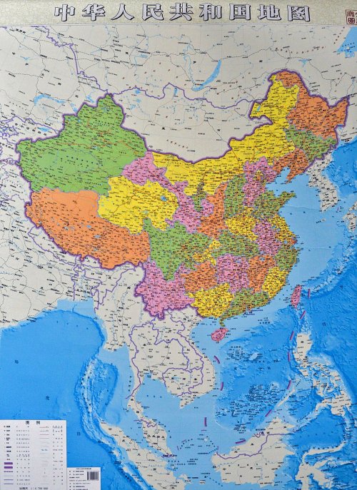
On June 25, 2014, Reuters reports that China has unveiled a new official map of the country giving greater play to its claims on the South China Sea by making the disputed waters and its numerous islets and reefs more clearly seem like national territory.
Although previous maps published by Beijing included China’s claim to most of the South China Sea, that claim was depicted in a little box in a bottom corner to enable the rest of the country to fit on the map. That placement made the South China Sea’s islands appear more like an appendage rather than an integral part of China.
The new, longer map dispenses with the box, and shows continental China along with its self-declared sea boundary in the South China Sea — stretching right down to the coasts of Malaysia, Vietnam and the Philippines — on one complete map.
An unnamed official with the map’s publishers told the Chinese government’s official newspaper People’s Daily that the new “vertical map of China has important meaning for promoting citizens’ better understanding of … maintaining (our) maritime rights and territorial integrity.”
H/t CODA’s M.S.
 Click map to enlarge. Note the purple dashes marking the South China and East China Seas as parts of China.
Indeed, China’s recent aggressive moves in the South China Sea, as well as last November’s declaration of an Air Defense Identification Zone over the East China Sea, are but indicators of an overall policy shift by the Chinese military from a land-based to an ocean defense strategy.
From p. 230 of Maria Hsia Chang’s Return of the Dragon: China’s Wounded Nationalism (Westview, 2001):
An article in [Beijing’s Guofang journal] National Defense in 1995 explains that, “In the past, for a long period of time,” humanity primarily relied on land for their survival and development, thinking that “national territory (guotu 国土) only meant dry land.” But in today’s world, due to rapid increases in population and dwindling land and resources, “national territory” must mean more than “land territory” (lingtu 领土) but should include “territorial waters” (linghai 领海). This has led nation-states to turn to the “oceans” (haiyang 海洋) — most of which are still “virgin territory” — in their search for new “living space” (shengchun kongjiang 生存 空间).
The PRC now conceives oceans to be its “second national territory” (dier guotu 第二 国土). It defines “maritime national territory” (haiyang guotu 海洋国土) as “the maritime portion of any land and space belong to or under the jurisdiction of a coastal country.” China’s “second national territory” includes 12 territorial seas (linghai 领海), 24 “maritime adjacent regions” (haili pilian qu 海里毗连区), 200 maritime economic exclusive zones and continental shelves — totaling more than 3 million square kilometers or one-third of China’s land mass.
Defense of its “national maritime territory” requires Beijing to shift its defense strategy from one of “coastal defense” (jin’an fangyu 近岸防御) to “offshore defense” (jinhai fangyu 近海防御). National Defense maintains that since “the frontline of maritime national defense lies beyond China’s territorial waters . . . there will be times” when China’s defense of its seas “may require doing battle in farther maritime regions” including “international waters and seabeds.” China’s perimeter of “offshore defense” is conceived to include two “island chains.” The first chain stretches from the Aleutians to the Kurils, the Japanese archipelago, the Ryukyus, Taiwan, the Philippine archipelago, and the Greater Sunda Islands. The “second island chain” comprises the Bonins, the Marianas, Guam, and the Palau archipelago.
See also:
- China in a frenzy to build nuclear attack submarines
- China threatens war in South and East China Seas
- China’s ADIZ is a strategic move to control First Island Chain
- PLA activities in First Island Chain
- China’s irredentist nationalism and the six wars to come
- Chinese H-18 stealth bomber’s nuclear weapons can reach Guam
- Dir. of US Navy Intelligence: Chinese Navy in drills to take Senkaku and invade Okinawa
- Taiwan think tank on China’s territorial ambitions and decisive military superiority by 2020
- U.S. Pacific Command Adm. Locklear says China is eclipsing U.S. in Asia
~StMA


Reblogged this on Brittius.
LikeLike
http://chinadailymail.com/2014/07/05/why-china-will-reclaim-siberia/
LikeLike
Thank you, futuret!
LikeLike
As the quote from Chang’s “Return of the Dragon” demonstrates, China has consistently maintained its claim over adjacent “territorial” waters in the East China and South China seas. What has changed over the past decade or so has been the fabrication of a military capability to project, support and defend those claims.The intention of powers is always interesting and important — but when intentions are married to capabilities — then the international community must, on pain of existential threat, be prepared to counter capability with capability. By design, the present administration in Washington is reducing U.S. military power. How that is to be understood in the present security environment is difficult to fathom.
LikeLike
Pingback: Dir. of U.S. Navy Intelligence sacked for warning about China’s aggressive designs in East China Sea -